Last Wednesday the 19th, I had the pleasure of attending a lecture from Beth Erddy, a recent PhD graduate from Washington State University as she spoke about U.S. Route 12 and its tumultuous history of construction through north central Idaho. This event was part of the Nez Perce National Historical Park's winter programming and was held at the visitor center in Spalding, Idaho.
 |
| Beth Erddy, PhD discussing her research regarding U.S. Route 12 through north central Idaho. |
Briefly I will summarize what I learned from the lecture. What became U.S. Route12 through Idaho was original the Lolo trail or Buffalo Trail as known by the Nez Perce and other Native American tribes and mountain men. People traveled over the trail to present day Montana to hunt buffalo and return to north central Idaho. The trail and future road traverses from Lewiston, Idaho over Lolo Pass. The road in Lewiston begins at an elevation of 745 feet above mean sea level (msl) while climbing to 5,233 feet msl at the top of Lolo Pass.
 |
| Beth Erddy, PhD discussing her research regarding U.S. Route 12. |
The road cut through rigorous terrain and even fiercer political battles which formed its funding. U.S. Route 12 was funded by many different state and federal organizations over time from 1918 when road construction began to 1962 when the road was completed. The road was a struggle because of the cost in completing it through the rough and unyielding terrain. In 1962 when the U.S. Route 12 was completed it was calculated to cost$142,574 per mile through north central Idaho.
I would like to close by thanking Beth Erddy, PhD for sharing her very interesting research with us and the Nez Perce National Historic Park for presenting the programming. I will close by posting a map of U.S. Route 12 through north central Idaho.
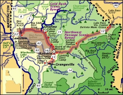 |
| Image courtesy of www.lewisandclarktrail.com . |
No comments:
Post a Comment